


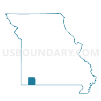
McDowell Voting District, Barry County, Missouri
About
Outline

Summary
| Unique Area Identifier | 607053 |
| Name | McDowell Voting District |
| County | Barry County |
| State | Missouri |
| Area (square miles) | 18.91 |
| Land Area (square miles) | 18.86 |
| Water Area (square miles) | 0.06 |
| % of Land Area | 99.70 |
| % of Water Area | 0.30 |
| Latitude of the Internal Point | 36.81552700 |
| Longtitude of the Internal Point | -93.79923930 |
Maps


Graphs
Select a template below for downloading or customizing gragh for McDowell Voting District, Barry County, Missouri


Neighbors
Neighoring Voting District (by Name) Neighboring Voting District on the Map
- Jenkins Voting District, Barry County, MO
- Kings Prairie Voting District, Barry County, MO
- McDonald Voting District, Barry County, MO
- Ozark Voting District, Barry County, MO
- Pleasant Ridge Voting District, Barry County, MO
- Purdy Voting District, Barry County, MO
Top 10 Neighboring County Subdivision (by Population) Neighboring County Subdivision on the Map
- Kings Prairie township, Barry County, MO (971)
- Ozark township, Barry County, MO (955)
- McDonald township, Barry County, MO (853)
- Pleasant Ridge township, Barry County, MO (486)
- Jenkins township, Barry County, MO (398)
- McDowell township, Barry County, MO (288)
Top 10 Neighboring Unified School District (by Population) Neighboring Unified School District on the Map
- Cassville R-IV School District, MO (11,765)
- Aurora R-8 School District, MO (11,098)
- Purdy R-II School District, MO (3,365)
- Verona R-VII School District, MO (2,395)